Economic Development of the Tennessee River Region
This collections seeks to understand how different entities depict the Tennessee River Valley region through mapping. The three maps included are made by three government organizations with profoundly different purposes. The analysis focuses on how natural features, rivers, lakes, and mountains, are represented. These different styles of representation indicate the different points of view of each different agency when it comes to developing the same landscape. Thus, these maps visually represent both the landscape and the economic potential of the region.
Tennessee Valley Area: pictorial map
This pictorial map, produced by the Tennessee Valley Authority, shows the Tennessee River Valley region with particular emphasis on the proposed work and improvements of the TVA. As the map notes, there is "no scale," nor does it include a compass…
Western North Carolina, a Vacationist's Map and Guide
This map produced by the North Carolina State Advertising Division illustrates the recreational opportunities of Western North Carolina. The Great Smoky Mountains and Blue Ridge Mountains form the geographic boundaries of the region; there are no…
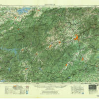
Knoxville
This large-scale topographic map covers the region between Knoxville, TN and Asheville, NC. As an official U.S.G.S., the map makes claims to objectively representing the landscape through topography. The consistency of representation across such a…


