National Narratives in Pictorial Maps, 1929-1939
This collection explores American pictorial maps from the 1930s. Their modes of representation and their content may differ, but they all represent an attempt at shaping and responding to contemporary national identity. Depicted beside and beneath the map's ostensible themes (food, natural resources, American history), is more subliminal messaging about race and American identity. The aesthetics of the maps vary, but they all depict the United States in approximately the same scale and style.
In my project, I hope to explore the arguments these maps were making. Further questions include: why was there an uptick in pictorial map making in this time? More broadly, how does the form of these pictorial maps relate to their function? What does the publishing power behind these maps -- one map was privately published, two were published by large food companies -- mean? How do these maps fit in to the larger historiographical discussion on the creation and consumption of culture during the 1930s? What is the connection to the Great Depression?
Map of the Gifts of Nature to America
This 1934 pictorial map was created by the Kellogg Company. The titular "Gifts of Nature" refers to agricultural plenty, but the map also depicts historical sites, industry, and Native American tribes. Also shown are railroad lines, migration routes,…
Map of America's Making, A Chart of Places and Events
This pictorial map depicts the history of the United States, with history seeming to be defined as colonial activity -- or even more broadly, white history (although it does record the historical locations of several Native American tribes). It…
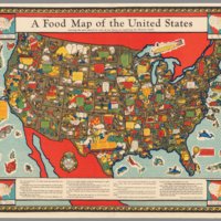
A Food Map of the United States
A 1930 pictorial map of the United States with a focus on the foods produced by each state. The colors of the map are vibrant, and the decoration stylized. Within each state, the artist/cartographer has drawn in imagery of the food products.…


