Wallace's Line
This collection displays snapshots of the career of Alfred Russel Wallace. Best known for his simultaneous discovery of evolution with Charles Darwin, Wallace is also notable for pioneering the discipline of biogeography. The maps in this collection show the arc of his career in exploration and theory related to the distributions of animal species. Wallace was trained as a railway surveyor before beginning his career in natural history, and mapping was a crucial part of his scientific thinking. The prelude to his essay describing the mechanism of natural selection was one describing how similar species arise coincident in space and time. His work on evolution was central to his career, but so too was his work delineating how different groups of species occupied different parts of the world. This collection features maps produced for Wallace's publications which visualize his process of creating geographical divisions based on animal life.
Map to Illustrate a Paper on the Physical Geography of the Malay Archipelago by Alfred Russel Wallace, Esq.
This map was published in 1863 in a paper by Wallace on the physical geography of the Malay Archipelago. It is the first map marking Wallace's line, here labelled as dividing the "Indo-Malay Region" from the "Austro-Malay Region". This line proposed…
Southern Part of the Malay Archipelago shewing Mr. Wallace's Routes
This map, published in Wallace's book describing his travels in the Malay Archipelago, shows the routes he took around the region while he was visiting the islands and collecting specimens there between 1854 and 1862. His occupation during these…
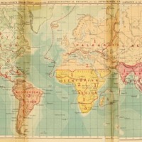
The World on Mercator's Projection Shewing the Zoogeographical Regions and the Approximate Undulations of the Ocean Bed
This map is the frontispiece of Wallace's book "On the Geographical Distribution of Animals. With a Study of the Relations of Living and Extinct Faunas as Elucidating the Past Changes of the Earth's Surface" (1876). This map shows the 6 regions into…


