Chinese Qing Empire's Mapping of the Northwestern Border
This collection is a series of Chinese Qing Empire (1644-1911)’s maps on its north-western borderline from the 18th century to 19th century. These maps show how the Qing Empire manipulated power on the newly conquered territory and how the Empire gradually failed its competition on territory with the Russian Empire (1721–1917). The time span of this collection covers the period of transformation in late imperial China: Western ideas and techniques were introduced, and the Chinese court and literati gradually tried to assimilate them into traditional framework of knowledge. The case of maps and cartography was no exception. In my final project, I plan to explore how the court and literati used and perceived maps.
Map of the New Domination
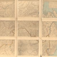
This map is an engraved map of the Chinese Qing Dynasty’s New Domination Province. Published around the 1860s, this map still follows the techniques of traditional Chinese Cartography. The grids on the maps help cartographer represent the landscapes…
Map of the Borderlines of China and Russia
This map, named The Map of the Borderlines of China and Russia, is a selected translation from one 1884 Russian map. Hong Jun (1839-1893), who had been the Qing Empire’s emissary, bought the original map in Russia and translated place names into…
Qing Empire's Complete Map of All Under Heaven
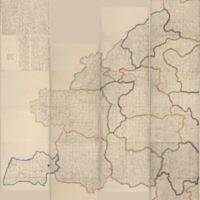
The Qing Empire under Emperor Qianlong (r. 1735-1795) was an age of expansion. After conquering the New Domination at the west, the Emperor sent missionaries there to do surveys. In 1761, basing on new surveys and the previous national map made under…


