Browse Items (82 total)
- Item Type: Historical Map
Sort by:
IsabellaC
This map, produced in 1944, shows major “tropical diseases” and where they occur in the world. A stylized image of the vector or symptoms of the disease is drawn over each afflicted region. Along the bottom of the map is a key describing which image…
Tags: artzybasheff, cholera, dengue, disease, fly, helminthic disease, IC, images, Japanese river fever, leishmaniasis, leprosy, magazine, malaria, mosquito, pests, plague, rat, relapsing fever, Rocky Mountain fever, sleeping sickness, text, tick, tularemia, typhus, world map, worm, yaws, yellow fever
HannahH
This map layer depicts Western Palestine at the time of the Old Testament. It sources its information primarily in the book of Joshua which chronicles the Israelites conquering and settling the Holy Land. However, there are additional place names,…
ClaireC
This map produced by the North Carolina State Advertising Division illustrates the recreational opportunities of Western North Carolina. The Great Smoky Mountains and Blue Ridge Mountains form the geographic boundaries of the region; there are no…
IsabellaC
Polar projection of the world
HannahH
This map presents the place names of western Palestine in Arabic and explains their meaning in a key on the side. It also marks the location of Arabic villages, churches and mosques. It is a notable that this map is included to the Palestine…
ChristinaS
This map shows the topographic survey and county lines of the area around the Los Angeles aqueduct as it makes its way from its source at the Long Valley reservoir north of the city down to the city itself.
AbigailP
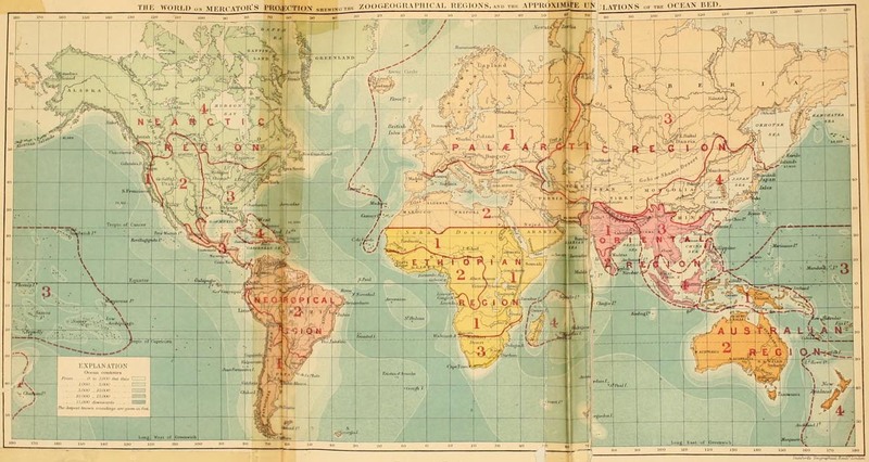
This map is the frontispiece of Wallace's book "On the Geographical Distribution of Animals. With a Study of the Relations of Living and Extinct Faunas as Elucidating the Past Changes of the Earth's Surface" (1876). This map shows the 6 regions into…
Tags: and city names, Australian region, biogeographical division line, continent outlines, contours of sea depth, dashed lines, desert labels, Ethiopan region, mountain range labels, Nearctic region, Neotropical region, numbers and outlines of subdivisions within biogeographical regions, Oriental region, Palaearctic region, region, selected country, shading of biogeographic regions, solid lines
JosiahC
Full Title: “(Text Page to) St. Paul, Minneapolis & Manitoba Ry. Red River Valley Line through the park region ... 2 +87. Matthews, Northrup & Co., Art-Printing Works, Buffalo, N.Y.”
My description: This text page advertisement from the…
My description: This text page advertisement from the…


